❌

リーディングビュー

Google Buys All of Spirit Airlines' Data to Feed Its AI Models

✇Slashdot
著者: BeauHD

🤖 AI Summary

Googleは、廉価航空会社のスピリット航空が5月に業務を停止以降、破産手続き中に販売していたデータ約10万ドル(約1,143万円)で取得したと報じられています。取得されたデータには、内部通信、スプレッドシート、予約やフリーファライターコンテンツ、取引情報、従業員情報などが含まれています。

個人を特定できる情報は削除されているものの、大量の有用な情報を提供しています。スピリット航空が業務を停止した後も、機材や不動産以外にも、このようなデータなどの価値ある資産が存在していることがわかります。

このデータはGoogleの人工知能モデルに利用されるとのことです。この事件に関連する記事は[Slashdot]で読むことができます。
Google has agreed to pay $10 million for a massive trove of anonymized Spirit Airlines data following the carrier's shutdown, including internal communications, spreadsheets, booking and frequent-flyer records, transactions, and employee information. CNN reports: Did you ever fly on Spirit Airlines? Or work there? Or send an email to someone who worked there? Then your information will soon be feeding Google's artificial intelligence model. The discount airline halted all operations in May, and it's been selling off its remaining assets through the bankruptcy process ever since. While most of that is planes, equipment, and real estate, there's other things that are valuable, too. It was disclosed late Monday that the company agreed to sell its data to Google for $10 million. That includes emails and internal communications, spreadsheets, transactions with the public including bookings and frequent flyer information as well as human resources information on its employees. The data has been stripped of anything that would allow individuals to be identified, according to the court filing. But it is still a massive amount of useful intelligence.

Read more of this story at Slashdot.

  •  

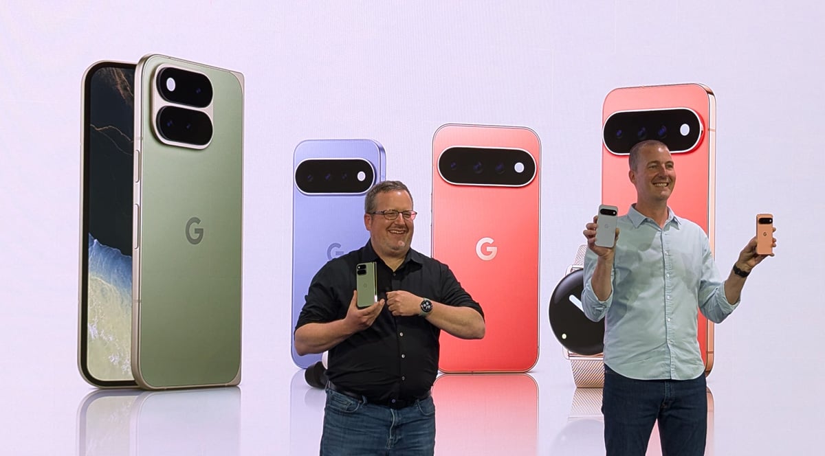
進化した健康管理とGeminiが先回りして提案する機能を搭載へ Googleのスマートウォッチ「Pixel Watch 5」を8月20日発売

Googleは8月12日、スマートウォッチ新製品「Pixel Watch 5」を発表。41mmと45mmの2サイズをラインアップして国内でも同日から予約受付を開始、8月20日に販売を開始します。健康管理機能では、ユーザーの目標に合わせてカスタマイズした提...続きを読む
  •  

The Pixel Tag Is Google's Answer To the AirTag

✇Slashdot
著者: BeauHD

🤖 AI Summary

Googleは29ドルのPixel Tagを発表し、AppleのAirTagとの競争商品として位置追跡機能をUWBとBluetooth 6.0 Channel Soundingを組み合わせたものだ。11月11日に販売開始予定。Pixel Tagは約12グラムで、一つの灰色(Fog)色の細長い装置であり、取り付け用のフックやクリップがついていない。電話を探すボタンがあり、防水・防塵規格IP67を満たしており、CR2032コインバッテリーを使用し、1つのバッテリーで1年以上持つと主張している。

GoogleのFind Hubネットワークとの互換性もあり、Bluetooth機能を持つAndroidデバイスを利用して失われたオブジェクトの位置を特定できる。UWBは、UWB搭載機種近接時に距離と方向を示し、Channel Soundingは距離のみを正確に示すが、全てのBluetooth 6.0対応電話やタブレットでも使用可能だ。現在ではMoto Tag 2しかこの機能をサポートしていない。
Google has unveiled the $29 Pixel Tag, its long-awaited AirTag rival that combines UWB with Bluetooth 6.0 Channel Sounding for two forms of precision tracking. It launches November 11. The Verge reports: The Pixel Tag is a slim oblong device available in one grayish color -- Fog -- that weighs about 12g, or 0.4oz. Like the AirTag, it has no built-in hooks or clips for attaching to objects you want to track. There's a single button that will trigger a sound on your phone, for the rare occasion when you've got the Tag but have lost your main device. It also has an IP67 rating, so it should be safe from dust and rain. As for the battery, the Pixel Tag takes CR2032 coin batteries, and says one battery should last for over a year. Naturally, it'll be compatible with Google's Find Hub network, which leverages the Bluetooth capabilities of Android devices worldwide to help locate lost objects. [...] Once you're close enough to the Pixel Tag, UWB lets the Find Hub app display the distance and direction to the tracker, so long as you're using a phone with a UWB chip. Channel Sounding is a newer development that can display the exact distance, but not direction, and it will work with any phone or tablet that includes Bluetooth 6.0. The Moto Tag 2 is the only other tracker to currently support it.

Read more of this story at Slashdot.

  •  

Googleが新スマートフォン「Pixel 11」シリーズを8月20日発売へ ProシリーズにはGeminiの応答や着信を光で知らせるHiLightを搭載

Googleは8月12日、Pixelスマートフォンの新製品4モデル「Pixel 11」「Pixel 11 Pro」「Pixel 11 Pro XL」「Pixel 11 Pro Fold」を発表。国内でも同日からGoogleストアで予約受付を開始し、8月2...続きを読む
  •  

Google's $15 Billion India Data Center Project Battles Water, Wildlife Concerns

✇Slashdot
著者: BeauHD

🤖 AI Summary

Googleの150億ドル級のインドビスケパトナデータセンター計画は、地元の水不足を悪化させる可能性とカンバラクンドダ保護区に野生生物の影響が及ぶ懸念から、反対運動や法的挑戦を受けている。Googleは高度な空調技術を使用し、インド法律に準拠することを主張しているが、州当局は住宅地や農村部への水供給からの分離を否定している。

アンダラプラハ政府はこのプロジェクトが地域の水供給と野生生物に対するリスクを十分検討せずに急いで進められたという批判を否定している。しかし、反対運動が増大し、Googleにとってインド最大規模の投資案件となるこの計画は早期に課題になる可能性がある。

最近数週間で、ビスケパトナ市では activistや子供たちが「データを飲めない」という看板を持ちながら街頭デモを行い、Googleロゴには手錠を描き付けたという動きが見られる。地元の非営利団体グリーンビサカの創設者ラジャ・ラマ・ムハンナ・ロイは、「開発は人々の生活を犠牲にしてはならない」と述べ、Visakhapatnam市における水需要と供給に関する統計を提示した。

政府によると、市の日用水量は410百万リットルで、必要な480百万リットル未満となっている。250万人の人口を持つこの都市では日常的に水供給制限が行われている。最高裁判所は、地元団体「ジャール・ビライダリー」による批判に対し政府を法的攻勢に立たせることを求めている。そして8月24日に地方法廷で公訴の可能性がある。

このプロジェクトは野生生物保護区に近接しており、そこでライオンや Pangolin も生息しているため、水供給面での圧迫が懸念されている。
Google's $15 billion data-center project in Visakhapatnam is facing protests and legal challenges over fears that it will worsen local water shortages and disturb wildlife near the Kambalakonda sanctuary. Google says the campus will use advanced air cooling and comply with Indian law, while state officials deny that residential or rural water supplies will be tapped. Reuters reports: The southern state of Andhra Pradesh, governed by an ally of Prime Minister Narendra Modi who has hailed the project as historic and transformational, has denied allegations that the project was fast-tracked without weighing risks to water supplies and wildlife. But the growing opposition could become an early test for Google's biggest-ever India investment, which is facing several legal challenges over its impact on water supplies and proximity to a wildlife sanctuary that is home to leopards and pangolins. In recent weeks, activists and children have marched in Visakhapatnam city, holding banners saying "We cannot drink DATA" and painting handcuffs on the Google logo, social media posts show. On Sunday, Reuters attended a public gathering where activists chalked out plans for holding door-to-door awareness campaigns and beach protests in coming days. "Development should not be at the cost of livelihood of the people," Raja Rama Mohan Roy, founder of non-profit Green Visakha said at the event where he presented statistics on Visakhapatnam's stressed water supply and demand. The government says the city receives 410 million liters of water a day from its reservoirs and rivers, against a requirement of 480 million. Rationing of water supplies is common in the city with a population of 2.5 million people. [...] The state's top court on Monday asked the government to defend against allegations leveled by activist group Jal Biradari (Water Community), which says the project will strain water availability by putting stress on a nearby reservoir. The Andhra Pradesh High Court will next hear the public interest litigation on August 24.

Read more of this story at Slashdot.

  •  

Google Overhauls AI Leadership As DeepMind CEO Steps Aside

✇Slashdot
著者: BeauHD

🤖 AI Summary

GoogleはAIリーダーシップを再編し、DeepMindのCEOであるデミス・ハサビスが日常的な管理から手を引き、アルファベットの最高科学顧問に就任することになりました。その代わりに、CTOのコーライ・カキュコグルーが実務的な責任を持つようになりました。

長期的にGoogleでAI研究を担当したジェフ・デインは、独立系の受益法人「ディスカバリーロープ」を設立し、同社の出資者とクラウド提供業者となっています。他の一同にSanjay GhemawatさんやOriol Vinyalsさん、Quoc Leさんも参加しています。

ハサビスはアルファベットの科学顧問として新しく追加された役職だけでなく、同社のAI製薬関連部門である「アイソメラック・ラボ」のリーダーでも留まります。デインは独立することで、より純粋なAIの科学的発見に焦点を当てられるようになったと述べています。

ハサビスは、「私たちは全人類にとって良い結果をもたらすために次のステップで正しいことを取り組むことが重要だ」と語っています。
Google is reshuffling its AI leadership as Demis Hassabis steps away from day-to-day management of DeepMind to become chairman and Alphabet's chief scientist, while CTO Koray Kavukcuoglu takes operational control. Meanwhile, longtime chief scientist Jeff Dean and several prominent researchers are leaving to launch their own company. Axios reports: Hassabis will add the title of chief scientist for Google parent company Alphabet and also continue to lead Isomorphic Labs, the company's AI drug discovery spinoff. Koray Kavukcuoglu, the current chief technology officer of Google DeepMind will serve as senior VP of the unit, reporting to CEO Sundar Pichai. Dean, a 27-year Google veteran is starting Discovery Loop, an independent publicity benefit corporation in which Google will be an investor and cloud provider. Joining him in that effort are Google senior fellow Sanjay Ghemawat as well as Oriol Vinyals, a DeepMind VP and Quoc Le, a Google Brain co-founder. [...] In an interview with The New York Times, Dean indicated that leaving Google, a public company, gives him more leeway to focus on scientific discoveries associated with AI as well. "We might make decisions that are not necessarily in the company's purist financial interests," he told NYT. "I've been working towards AGI my whole life and now, like many of you, I feel it is close at hand," Hassabis wrote. "It's critical that we collectively get the next steps right to ensure this all goes well for humanity and we usher in an incredible new age of discovery and wonder." "With this backdrop, I've decided that now is the right time for me to hand over my day-to-day operational responsibilities at GDM, so that I have the time and space to focus on the big picture and help influence what is to come to the best of my ability"

Read more of this story at Slashdot.

  •  

Group of Teen Hikers Relied on Google Maps. It Was a Disaster.

🤖 AI Summary

>Title: ティーンエイジのハイキンググループ、Googleマップ依存が大失敗に

### 要点:
1. **事件概要**:ティーンエイジのグループがブリティッシュコロンビア州の HOWE SOUND CREST TRAIL をハイキング中に予想外の大変な状況に直面した。Google Maps は約5時間で完了すると示唆していたが、実際には夜遅くまで続けられ、疲労、脱水症状、けががあり、ヘリコプター救出が必要となった。

2. **ハイキングの難しさ**:このトレイルは18マイル(約29km)、6,000フィート(約1,830m)の標高差で、経験豊富なランナーでも1日で完走出来る。しかし、探査隊の関係者は通常2泊用意するよう推奨している。

3. **失敗の原因**:グループは Google Maps の推定5時間に依存し、少ない水量と食料だけを持ち出し、脱水症状や筋肉痛が発生。天色が暗くなる前に下山することを決めたが、一人が岩から転落して尾骨を壊したためヘリコプター救出が必要となった。

4. **教訓**:マップや情報はあくまで参考であり、実際のハイキングには適切な準備と判断力が求められる。Google Maps の時間推定は舗装路での直線移動を前提しており、自然環境では有効でない可能性がある。

### 参照:
- 原文:[Group of Teen Hikers Relied on Google Maps. It Was a Disaster.](https://tech.slashdot.org/story/26/08/01/0552202/group-of-teen-hikers-relied-on-google-maps-it-was-a-disaster)
"When a group of teenagers set out to hike British Columbia's famed Howe Sound Crest Trail in early July, Google Maps suggested the trek would take about five hours," reports SFGate. "Instead, the hike stretched deep into the night, leaving the group exhausted, dehydrated, injured and in need of a helicopter rescue..." Although the approximately 18-mile route with a 6,000-foot elevation gain can be completed by experienced trail runners in a day, search and rescue officials generally recommend hikers treat it as a two-day backpacking trip. The teenagers, all 17 years old, believed Google Maps' estimate that the route would take about five hours. The printed directions they were carrying, which were shared publicly by Lions Bay Search and Rescue, gave simple instructions for two legs of the trail, but didn't account for the terrain or elevation. "[Google Maps] is calculating the time that you're walking a straight road on pavement," [said Maria Masiar, training officer and search manager with Lions Bay Search and Rescue]. "When you get into outdoor terrain, that no longer holds true." Expecting only a short outing, each hiker carried about half a liter of water and limited food. There are no reliable water sources along the trail, meaning hikers must carry enough supplies for the entire route. As the group climbed, they began suffering from dehydration and muscle cramps but continued onward despite falling dramatically behind schedule. Eventually, the group made the decision to turn back and abandon making it to the end of the trail — and as the sun began to set and the group started to descend, fatigue took its toll. According to Masiar, members of the group had already stumbled and fallen several times while trying to race the coming dark, and only one hiker had a headlamp. Eventually, another hiker slipped about 10 feet off a boulder, injuring his tailbone badly enough that he could no longer continue. Search and rescue crews responded, ultimately evacuating him by helicopter.

Read more of this story at Slashdot.

  •  
❌